Nestled at 2,792 meters above sea level in Peru’s Urubamba Valley, Ollantaytambo is both an Andean town and an archaeological marvel. Its stone streets and terraced hillsides reveal centuries-old infrastructure, blending daily life with monumental Inca legacy. For travelers seeking historical depth and authentic local atmosphere, Ollantaytambo stands apart from other stops on the Sacred Valley route.
The Origins and Strategic Importance of Ollantaytambo
The roots of Ollantaytambo reach back to pre-Inca times. Archaeological evidence suggests that the site was originally inhabited by the Tampus people, whose settlement on the slopes of Bandolista Hill formed a small regional center. The area’s strategic location—at the confluence of the Urubamba and Patacancha rivers—made it a natural crossroads for trade, agriculture, and defense.
In the mid-15th century, Pachacuti Inca Yupanqui, one of the most influential rulers of Tawantinsuyu (the Inca Empire), conquered the territory. He initiated an ambitious urban reconstruction project, transforming Ollantaytambo into part royal estate and part administrative center. Recent studies indicate the sophisticated planning found in its layout was a direct result of imperial investment; features such as perfectly aligned streets, advanced irrigation channels, and agricultural terraces reflect both engineering acumen and religious symbolism.
Ollantaytambo later played a key role during the Spanish conquest. After Cusco fell in 1536, Manco Inca—leader of the resistance—made Ollantaytambo his stronghold. The site thus gained lasting historical relevance as one of few places where Inca forces managed to repel Spanish attacks, at least temporarily, before retreating into Vilcabamba.
The Urban Layout: A Living Inca Town
What makes Ollantaytambo unique among Andean sites is its continuity as a living settlement. Unlike Machu Picchu or Pisac, whose principal structures are uninhabited ruins today, Ollantaytambo’s core grid remains home to a community descended in part from original inhabitants. Walking through its narrow cobbled lanes—such as Calle del Medio or Callejón del Sol—you will find centuries-old canchas (communal family compounds) still occupied, their high stone walls preserving both privacy and tradition.
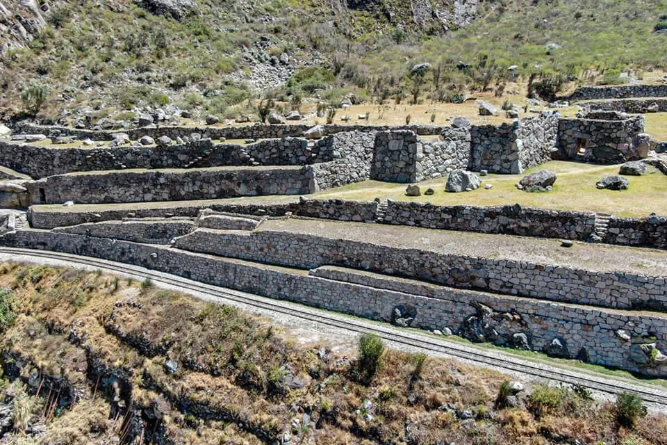
The town’s urban plan follows classic Inca design principles: long straight streets intersected by others at right angles form city blocks surrounded by water channels. Each block typically contains several rectangular dwellings opening onto a central courtyard. These arrangements maximized communal resources while providing structural stability against earthquakes—a lesson modern architects continue to analyze.
One distinctive element is the network of open-air water channels running alongside most streets. These were engineered to divert glacial meltwater efficiently throughout the settlement, supplying homes and small agricultural plots even during dry seasons. Such infrastructure not only met practical needs but also held ritual significance; water was associated with purification and fertility in Andean cosmology.
Archaeological Highlights: Temples, Terraces, and Storage Complexes
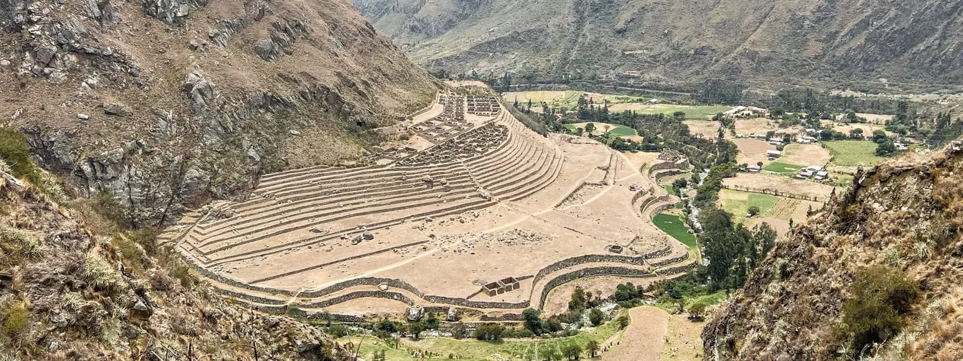
The Ollantaytambo archaeological zone occupies a prominent hillside overlooking the town proper. It comprises several sectors reflecting different functions within Inca society—ceremonial, administrative, defensive, and agricultural.
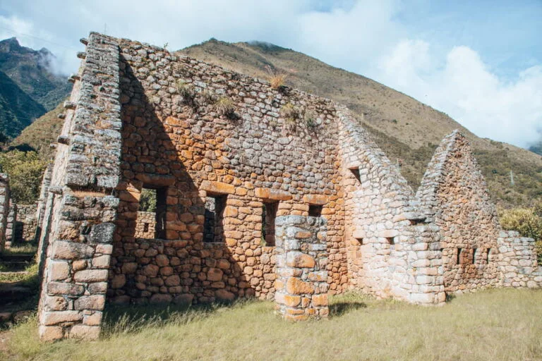
At its summit stands the so-called Temple Hill or “Fortress” (though scholars debate whether it served primarily military or religious purposes). Here visitors encounter imposing terraces—over 16 meters high in places—supporting massive walls built from precisely cut rhyolite blocks transported from quarries more than six kilometers away across the valley. The scale of this labor demonstrates not only technical prowess but also centralized control over labor resources.
Key architectural features within this complex include:
- The Temple of the Sun: Six monolithic stones form an unfinished wall facing east; symbols such as pumas and stepped motifs echo celestial themes common across major Inca sanctuaries.
- The Intihuatana: This carved stone pillar functioned as an astronomical marker used to determine solstices—a vital reference for agricultural cycles in preindustrial societies.
- The Baño de la Ñusta: An elegantly sculpted fountain system reputedly reserved for noblewomen or ritual use; its three spouts exemplify water management techniques and attention to ceremonial purity.
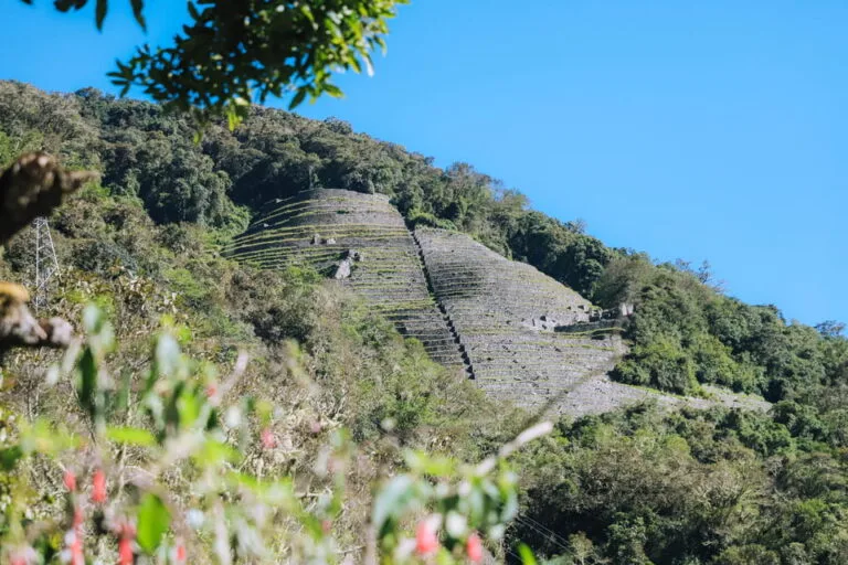
- Cerro Pinkuylluna Storehouses: Located across the valley, these granaries (qolqas) were placed at high elevations to benefit from cool winds that slowed spoilage—a practice documented by early chroniclers such as Pedro Cieza de León.
Pachacuti’s Vision: Urban Planning Meets Ideology
The transformation of Ollantaytambo under Pachacuti represented more than construction prowess—it expressed imperial ideology through spatial organization. Key elements such as trapezoidal doorways, interlocking masonry joins, and precise solar alignment recur throughout the complex. Their technical sophistication continues to generate debate among archaeologists regarding construction methods; some suggest ramps, levers, and large human crews would have been necessary for moving multi-ton stones across river gorges.
Pachacuti’s vision also extended to social engineering: imported colonists (mitmaqkuna) from other regions helped populate strategic settlements like Ollantaytambo. This encouraged cultural integration within newly conquered territories while ensuring loyalty to Cusco’s central authority. Ethnohistorical records indicate that certain neighborhoods trace origin stories back to coastal or Amazonian groups relocated by imperial decree—a pattern that shaped both daily life and long-term demographics.
Irrigation systems installed alongside terraces supported diverse crops ranging from maize (a ritual staple) to native tubers such as oca and mashua. The juxtaposition of large-scale infrastructure with household gardens demonstrates an integrative approach to agriculture that balanced state needs with local autonomy—a strategy echoed in other major centers but especially visible here due to ongoing cultivation practices.
Cultural Layering: Myths, Rituals, and Living Traditions
Beyond architecture, Ollantaytambo's identity is shaped by layers of mythic narratives and persistent rituals. Quechua oral traditions recount stories linking place-names (toponyms) with legendary figures—most famously Ollanta, a warrior whose tragic love affair inspired one of colonial Peru’s earliest dramatic works (“Apu Ollantay”). While some historians dispute direct connections between this narrative and specific sites in town, performances based on these themes remain part of festival calendars.
Ritual cycles correspond closely with agricultural work; festivals such as Cruz Velacuy (May) or Saint James’ Day integrate Catholic icons with indigenous offerings to apus (mountain spirits). During Inti Raymi (June), community members gather at sacred locations—including platforms above Temple Hill—to observe sunrise ceremonies reminiscent of pre-Columbian solar worship.
Textile weaving is practiced by many households using backstrap looms; traditional patterns incorporate Chinchero-style geometric motifs alongside iconography unique to Patacancha Valley communities nearby. Such crafts are not mere souvenirs but transmit histories through color codes and design sequences recognized within local kinship networks.
The Spanish Conquest: Resistance at Ollantaytambo
When Francisco Pizarro’s forces advanced into Tawantinsuyu in 1536–37 following their capture of Cusco, Manco Inca Yupanqui retreated toward Ollantaytambo. Here he fortified existing defenses using hastily constructed parapets atop existing terraces—archaeological layers show modifications consistent with conflict-era repairs.
In January 1537, conquistadors led by Hernando Pizarro attacked from below but withdrew after encountering fierce resistance combined with innovative tactics; chronicles note flooding caused by redirected canal waters hampered cavalry advances while sling stones rained down from defenders above.
Although this victory proved temporary—the Inca court soon escaped deeper into Vilcabamba jungle—the episode remains one of few documented instances where European military superiority was thwarted on Andean terrain using indigenous knowledge.
Remnants of these adaptations remain visible near main staircases ascending Temple Hill: enlarged defensive walls contrast noticeably with earlier construction phases.
Ollantaytambo Today: Gateway to Machu Picchu—and More Than a Stopover
Modern Ollantaytambo serves multiple roles: archaeological park managed by Peru’s Ministry of Culture; transit hub for rail journeys to Machu Picchu Pueblo (Aguas Calientes); vibrant Quechua-speaking town with an active agricultural base.
Tourist flows are intense during peak months (June–September), yet mornings before day-trippers arrive—and evenings after last trains depart—reveal a quieter rhythm marked by local markets on Plaza de Armas or children playing soccer along riverbanks.
Accommodations range from simple guesthouses housed in colonial-era buildings to boutique hotels occupying restored canchas.
While some businesses cater almost exclusively to international visitors—offering Western-style menus or English-language guides—numerous family-run ventures prioritize regional cuisine: quinoa soups flavored with huacatay (an aromatic herb), chicha morada made from purple corn harvested nearby.
Community-based tourism projects exist in surrounding villages such as Willoq and Patacancha; here visitors can arrange homestays or workshops focused on weaving practices little changed since pre-Columbian times.
Despite increased visitor numbers since rail lines expanded in recent decades, conservation efforts continue—balancing economic opportunity with preservation concerns remains an ongoing challenge addressed jointly by residents’ associations and cultural agencies.
The Landscape Around Ollantaytambo: Natural Features and Hiking Routes
Surrounding Ollantaytambo, dramatic geography frames every view: steep-sided mountains rise abruptly above river valleys cut deep by glacial runoff.
Pinkuylluna hill dominates the northern skyline; its slopes are studded with ancient granaries accessible via narrow footpaths requiring sturdy footwear but offering unparalleled vistas over rooftops below.
Other recommended hikes include:
- Pumamarca: A two-hour trek westward leads to another set of well-preserved ruins once integrated into regional defense networks; wildflowers bloom seasonally along irrigation canals reused since antiquity.
- The Cachiccata Quarry Route: This strenuous ascent toward abandoned quarries reveals unfinished blocks intended for Temple Hill construction—a striking visual demonstration both of logistical ambition and historic interruption caused by invasion.
- The Inca Trail Linkages: Several alternative trails depart directly from Ollantaytambo toward short sections of original Qhapaq Ñan roadways connecting subsidiary sites not accessible by car.
Culinary Life: Food Markets and Regional Dishes in Ollantaytambo
Life in Ollantaytambo revolves around tightly-knit neighborhoods where daily routines still follow seasonal agricultural cycles.
The municipal market near Av. Ferrocarril offers insight into what locals eat: potatoes (dozens of varieties), broad beans (habas verdes), rocoto peppers, chuño (freeze-dried potatoes), maize kernels destined for mote or chicha.
Visitors may encounter dishes rarely seen elsewhere:
- K’apchi de habas: A hearty vegetarian stew featuring fava beans mixed with cheese curds and mint-like huacatay.
- Pachamanca: Occasionally prepared for community gatherings; meats, tubers, corn baked underground over hot stones—a practice found throughout central Andes but celebrated communally here during rural festivals.
- Sopa de quinua: Quinoa soup enriched with vegetables grown on terraces just above town limits.
- Cuy al horno: Roasted guinea pig served mainly on special occasions like patron saint feasts rather than daily fare.
- Mazamorra de maíz morado: A purple corn pudding flavored with fruits when available during harvest months.
Contemporary restaurants blend traditional flavors with lighter presentations catering to changing palettes among younger generations without discarding indigenous techniques.
Linguistic Identity: Quechua Language Use in Everyday Life
One element defining Ollantaytambo's distinctiveness is continued use of Quechua language alongside Spanish.
Children learn Quechua at home before acquiring Spanish at school; signage throughout public spaces acknowledges bilingual reality.
Market vendors often switch languages depending on customers’ origins—a reminder that cultural identity here is maintained through oral transmission rather than written record alone.
During festivities or communal work days (faenas comunales), Quechua proverbs punctuate speeches delivered by village leaders (varayoqkuna).
This linguistic resilience counters homogenizing pressures brought by mass tourism; grassroots organizations promote intergenerational workshops where oral histories are recorded for future use without relying exclusively on external media.
For linguists studying Andean language persistence—or educators aiming for inclusive curriculum design—Ollantaytambo provides valuable case studies demonstrating how language policy unfolds outside metropolitan contexts.
Sustainable Tourism Challenges: Balancing Conservation With Community Needs
As popularity grows due partly to proximity with Machu Picchu train departures/arrivals (official schedules here) pressure increases on infrastructure originally built for smaller populations.
Local authorities have implemented restrictions regulating bus access near main square during peak hours; heritage organizations advocate limiting group sizes entering archaeological zones simultaneously.
Conservation projects prioritize restoration using traditional materials where feasible—adobe patchwork repairs complement original stonework rather than masking it behind cement facades.
Critically endangered plant species along canal banks receive protection via fenced buffer zones managed jointly by neighbors’ committees (UNESCO Qhapaq Ñan listing details conservation status regionally).
Frequently Asked Questions
- Is Ollantaytambo worth visiting if I am already going to Machu Picchu?
If you are interested in living history and experiencing both vibrant local life and archaeological wonders side-by-side, Ollantaytambo provides context unavailable at Machu Picchu itself. Its combination of functioning town structure with monumental ruins is unique within Peru’s Sacred Valley region. - How difficult is it to climb up Ollantaytambo's terraces?
The ascent involves numerous steep stone steps lacking handrails in places; moderately fit visitors should be able to reach main viewing platforms in about 20–30 minutes depending on pace. Those sensitive to altitude may wish to proceed slowly or rest along intermediate terraces before continuing higher. - Are there guided tours available locally?
A range of certified guides offer tours directly outside main ticket offices or can be arranged through hotels/agencies in advance. It is possible to request tours emphasizing archaeology, botany, history or local legends based on your interests; English-Quechua-Spanish trilingual guides are commonly available during high season. - What does "Tambo" mean in "Ollantaytambo"?
"Tambo" is a Quechua term adopted widely in Andean Spanish referring historically to inns or way stations supporting travelers across Inca road networks. At Ollantaytambo it denotes both storage/administrative facilities as well as hospitality functions embedded within urban planning since imperial times. - Can I visit Pinkuylluna storehouses independently?
The trails up Pinkuylluna slope are unsigned but freely accessible year-round unless closed for maintenance after heavy rains. Hikers should bring sturdy shoes and sun protection as paths become steep quickly—there are no entry fees but no formal supervision either so basic caution is advised especially outside daylight hours.